

God’s Country Marathon
THE NORTHEAST Extension of the Pennsylvania Turnpike runs from the Plymouth Meeting Mall just north of Philadelphia to Clarks Summit, in the very heart of the Pocono Mountains. Traveling north on any given weekend in early December, you can keep a running tally of Christmas trees versus deer strapped to the roofs of southbound SUVs. Average score is trees 37, deceased deer 2.
Travel two hours west and one hour north to north-central Pennsylvania, specifically Tioga and Potter Counties, and the count is exactly the opposite. Christmas trees are literally in the backyard for the cutting, and deer are frequently hiding behind the trees, likely dreading big-game season. In Potter County, the homes, where you can find them, are situated on anything from quarter-acre lots up to 20,000 acres if you’re fortunate enough to have your property line butt up against state game lands or state forests. The entire county is only 1,081 square miles, more than a third of which is owned by the Commonwealth of Pennsylvania.
Potter County has a population of 18,080 fine folks. During the 2000 hunting season, 4,941 antlered buck-type male deer were harvested. An additional 4,750 doe-a-deer-a-female-deer (aka, antlerless four-legged white-tailed critter) were served up for the dinner table. In northern Pennsylvania, these figures are significant. Consider venison steaks, roasts, and burgers for a family of five, paid for with a hollow-point .270 or .30-06 bullet, and deer become a major part of the Potter County economic outlook. Deer 37, Christmas trees 2.
Those 1,081 square miles that make up Potter County contain two “major” towns: Galeton, formerly Pike Mills, and Coudersport, the county seat. Other communities in the county include Shinglehouse, Oswayo, and Ulysses to the north and Austin to the south.
Austin is notable for its “Dam big disaster.” A 350-foot-wide and 50-foot-high concrete dam was built on Freeman Run to supply water to the pulp and paper company mill. It held back 250 million gallons of water—until the morning of September 30, 1911, when the dam let loose and all but destroyed the towns of Austin and Costello. Eighty-nine citizens lost their lives. The remains of the concrete structure can be seen from Route 872, just north of Austin. The dam was added to the National Register of Historical Places in 1989.
SCENIC—AND LONG—ROUTE 6
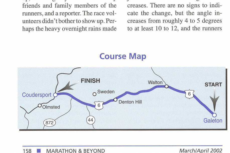
Galeton and Coudersport are located on scenic Route 6 exactly 22 miles apart. Route 6 runs from the tip of Cape Cod all the way to California. The 3,600-mile highway was originally built through northern Pennsylvania to make a connect-the-dots from one county seat to the next.
On or very near Route 6 is the home of Zane Grey on the Delaware River at Lackawaxen, which is spanned by the oldest wire suspension bridge in the Western Hemisphere—it inspired the Brooklyn Bridge. There is also a tour of the Lackawanna Coal Mine, some 300 feet underground.
Coudersport was first surveyed by the Ceres Land Company in 1807. The courthouse was built in 1835, and the borough was incorporated in 1848. The town jumped to more than 3,000 people after the construction of the Coudersport and Port Allegany Railroad in 1882. One of the claims to fame of Coudersport is the fact that the Underground Railroad passed through it during the Civil War. Fugitive slaves passed through the local “stations”: the store of John S. Mann, the farm of Nelson Clark, and the homes of Sala Stevens, Rodney Nichols, and John King. The fugitive slaves were assisted from there across the border into Canada.
Galeton—on the eastern side of Potter, on the Tioga County line—was renamed for William Gale and his son Loring, industrialists who owned the tannery. The population jumped from 281 to 5,000 within 30 years of the opening of the tannery, the railroad, and the local sawmills.
Current history is more vague. It’s difficult to pinpoint just who decided 27 years ago that the 22-mile stretch of scenic Route 6 from Galeton to Coudersport would make a fine marathon course. The point-to-point course has very few twists and turns. There are a few minor ones at the start and a few at the finish and a 2.6-mile dogleg in the first third of the course, but the rest is Route 6 right-of-way. From a profile standpoint, the course is 17.5 miles of climb, followed by a 2-mile drop, then flat to the finish. This difficult course offers over 1,100 feet of climb—starting at 1,300 feet and reaching 2,424 feet at its highest point.
Race registration for the Saturday morning race (including shirt and number pickup) is in the Galeton High School gym. At 6:35 A.M., the parking lot was completely empty and gym doors were locked. There was a jackhammer operator breaking up part of the parking lot between the junior and senior high school buildings. A fog-shrouded drive west along Route 6 disclosed two volunteers in a large dump truck setting the three-mile marker alongside the road, as well as dropping off cups, tables, and 2-1/2 gallon jugs of water.
Another five miles along the beautiful green mountains, whose peaks and valleys were only partially visible through the low-hanging clouds, two bright yellow school buses full of runners appeared. The buses leave the CARP (Coudersport Area Recreation Park) at 6:20 A.M. for a 7:00 A.M. arrival at the Galeton High School. The cost for transportation from the finish to the start is four dollars. By
| PHONE: | 814/435-2290 |
| FAX: | 814/435-8230 |
| E-MAIL: | potter@penn.com |
| WEB SITE: | pavisnet.com/marathon |
| RACE DIRECTOR: | c/o Potter County Visitors Association |
| YEAR RACE ESTABLISHED: | 1974 |
| CERTIFIED: | USATF #PA98010WB |
| TYPE OF COURSE: | Point to point |
| START TIME: | 8:00 A.M. |
| COURSE RECORDS: |
Open men: Terri Stanley, Eldred, PA, 1981, 2:25:12 Open women: Jacquie Merritt, West Chester, PA, 2001, 2:50:12 Team: Human Energy Club, Johnstown, PA, 2:38:16 average (total of 7:54:49): Eldred Himworth (2:35:15), Steve Molnar (2:38:14) and George Murphy (2:41:20) |
| PRIZE MONEY: |
Grand total: $3,500 1st male and female: $1,000 each 2nd male and female: $500 each 3rd male and female: $250 each |
| TIE-IN EVENTS: | team race (total of 3 marathoners) |
| NUMBER OF VOLUNTEERS: | 80+ |
| MARATHON FINISHERS IN 2001: | 126 |
| MALE/FEMALE FINISHERS: | 79 percent male; 21 percent female |
| COURSE MARKINGS: | every mile |
| WATER STATIONS: | roughly every other mile marker |
| FUTURE RACE DATE: | 01JUN02 |
| ENTRY COST FOR 2001: | $25 |
| AWARDS: | Men: 3 awards in 13-19, 3 awards in 20-29, 4 awards in 30-39, 6 awards in 40-49, 4 awards in 50-59, 3 awards in 60 and beyond. Women: 3 awards in 13-19, 3 awards in 20-29, 3 awards in 30-39, 3 awards in 40 and beyond |
| AREA HOTELS: | Your best bet for reserving lodging is to log on to pottercountypa.org and then choose the accommodations link. |
| GETTING THERE: | Potter County is 3 hours north of Harrisburg, 4 hours from Philadelphia, 6 hours from New York City and Washington, D.C., 9 hours from Boston, and 10 hours from Chicago. The roads are two-lane country roads that make for great fun in a sports car but great frustration if you’re looking to make great time. Be ready to take your time and enjoy the mountains and hairpin turns. Watch out for deer, an occasional bear, and every once in a while a wayward cow. |
Must See/Must Avoid
POTTER COUNTY in north-central Pennsylvania, on the New York State border, is most famous as a deer-hunting mecca in the early part of winter rather than as a traditional tourist attraction. Don’t let that claim to fame fool you. The county is full of beautiful attractions and the people, although unique in their adaptation to the rugged and remote territory, are open and friendly.
GO SEE IT
Pine Creek Gorge (aka, Pennsylvania’s Grand Canyon). Though not offering quite the splendor of the real Grand Canyon, this site is well worth the short trip from downtown Wellsboro. Leonard Harrison State Park is on the east rim, and Colton Point State Park is on the west rim. Both are easy drives from scenic Route 6. The maximum depth of the canyon is 1,450 feet on the southern end. The depth at the state parks is 800 feet, and it is more than 4,000 feet across. Drive slowly, as deer cross at will along the roads. You might even round a turn and find a loose bovine stalled in the middle of the two-lane country roads. We did.
The Pennsylvania Lumber Museum (just off Route 6 at Denton Hill) offers everything from tools to a logging locomotive. Over 3,000 artifacts are on display depicting an era when hemlock and white pine were the wealth of the nation. A sawmill and wooden buildings of a time long gone are the highlights of a slow walk back in time. There are 85 miles of hiking trails nearby in this Appalachian Mountain wilderness. Call 814/435-2652 for hours of operation.
Black Forest Trading Post and Deer Park. Some 8.4 miles from the start of the God’s Country Marathon, this unique gift, toy, and souvenir shop has something for everyone. Collectibles include Byers Choice, Michael Garman, Daniel Monford, Mill Creek Sculptures, Fenton Art Glass, Bradford Baskets, Case Knives, Boyds Bears, and Minnetonka deer skin moccasins. Kids love feeding the fallow deer, and even adults enjoy searching the sluice box for quartz, ruby, topaz, crystal points, sapphire, moonstone, amazonite, blue calcite, pyrite, and even garnet. This interesting shop is located on the corner of Routes 6 and 499 in Ulysses, Pennsylvania. The phone number is 814/435-6754.
Sports Car Club of America Pro Car Rally. Just like you see ’em on Speedvision: Saabs, Mitsubishis, Fords—all like you’ve never seen them before, up close and dirty. Old logging roads are used for this famous display of horsepower. The official name of the race is the Susquehannock Trail Pro Rally, and it’s run the first weekend in June, the same weekend as the God’s Country Marathon. The race begins on Main Street in Wellsboro at 10:00 a.m., and the timed and measured event continues in stages for three days. Call 570/724-1926.
Route 6. More than a journey, it’s a destination. “Glide through National Forests, climb Endless Mountain, follow the gentle bends of an impatient river, and retrace the historic trails traveled by pioneers.” National Geographic calls Pennsylvania Route 6 “one of America’s most scenic drives.” Look for country inns, bed and breakfasts, hotels, stores, restaurants, scenic views, and a charming early 1900s downtown.
AVOID
Nothing. This is simply a beautiful unspoiled part of America.
the time we made the return trip to the school, two hardy volunteers were setting up a water table at the dogleg section of the course across the road from the Black Forest Trading Post.
ACTIVITIES AT THE GYM
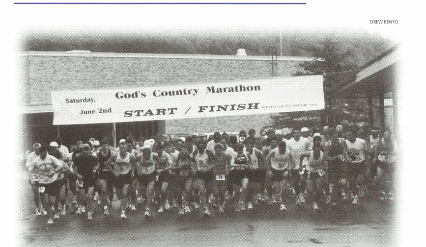
By 7:20 a.m. the high school gym was buzzing with activity. The usual pre-race hubbub predominated: trying on the colorful T-shirts, attaching bib numbers, frequent trips to the rest rooms, applying Vaseline to sensitive areas of the body. Family members exchange hugs and kisses, photos are taken of runners as they stand under the start/finish banner, Power-Aid is consumed toward ultra-hydration, and two young children play on the large bell near the entrance to the school.
Some 153 runners had registered for the 27th edition of the God’s Country Marathon; 136 actually showed up, and 126 finished. This is a slight increase over the past few years but well off the 350 starters who toed the line back in the early 1980s for the climb over Denton Hill Summit. Terri Dennison, the very accommodating and pleasant race director, assembled the field in the shadows of the school building as skies gradually began to brighten. The gun went off at exactly 8:00 a.m. and so did the runners.
The Galeton police car leads the field off the school grounds, which involves instantly making a 45-degree turn. Then there is a left across the bridge over Pine Creek, followed by a right turn to bring the runners parallel to the creek. There is another right, past the local State Store (wine and liquor) and the Exxon station, before a hard left onto Route 6, where the field encounters the one-mile marker. And then the climb begins.
Just before the 2-mile point is the site of the Friday evening “all you can eat spaghetti dinner,” the Ox Yoke restaurant. Actually, that’s the shorthand name—the full name is the Ox Yoke Cocktail Lounge, Inn, Family Restaurant, Motel, Cabins, and Campground. Their sign proudly promises color TV.
The mountains are still fog-shrouded, and the road continues to climb as runners pass the SMC Powder Metallurgy plant on the left at 4.6 miles. The next landmark is a few hundred feet before mile 5 and is worth noticing. It is a Korean War era Jeep—the sort Radar O’Reilly shipped back home in boxes to Ottumwa, Iowa. This rusty, baby blue jeep has been sold but still has a for sale sign painted in its window. The sight of it breaks the drudgery of the endless climb on a long straightaway.
Just beyond the 8-mile point, a sign with an arrow instructs runners to cross the highway. This portion of the course is a 1-1/2-mile straight, but there are no crossing guards. The right turn at 8.4 miles has a water stop set up, an emergency station manned by friends and family members of the runners, and a reporter. The race volunteers didn’t bother to show up. Perhaps the heavy overnight rains made them think the race would be cancelled. Or maybe they overslept.
The turn puts the runners onto Route 449, 8 miles from Gold and 16 miles from Genesee in Ulysses township. This is the dogleg, and the 1.3-mile downhill is the first descent of the race. One runner was heard to exclaim: “Wow! What the hell is this? I forgot how to run down hills.” Just a bit more than a mile later, runners quickly forget about running with gravity and are once again working against it.
AN INCREASE IN ANGLE
Coming out of the dogleg, runners are once again on their own as far as crossing Route 6 near the 11-mile mark. The course continues uphill, and the road is very, very straight. Then, to throw in more of a challenge, just before mile 14 the grade increases. There are no signs to indicate the change, but the angle increases from roughly 4 to 5 degrees to at least 10 to 12, and the runners have yet to reach Denton Hill, where it increases to 30 degrees.
The intersection at mile 14 has the left branch going to the Denton Hill Ski Area. Those brave enough to look that way get a preview of the 3.6-mile climb ahead of them. Those not so bold or foolhardy can look to the right at the Pennsylvania Lumber Museum. The museum is educational and entertaining, detailing the history of logging in north-central Pennsylvania.
The climb up Denton comes in a series of two steps. The first is from the entrance to the ski area and is a straight climb of about a third of a mile. It then levels off after a sharp left turn. But that moment is brief before runners enter an S-turn climb. Once out of the turn, all that runners see is more hill and sky. There is an aid station, and a sign on the right proclaims Denton Hill Summit, Allegheny Mountains, Elevation 2,424 feet.
Take a deep breath, give a sigh of relief, and hold on for dear life. The downhill slope is a roller-coaster ride. All the ground that the runners worked so hard to climb is returned in a mere 1.4 miles. At mile 19, the highway finally levels off and continues pretty much flat for the rest of the course.
At mile 20.2 there’s a turnoff for the Rainbow Paradise Fish Farm. Mile 22 has an historic marker for the Jersey Shore Pike. Mile 23 has the Pure Carbon Company on the left. At mile 24.5, runners pass the Coudersport Junior High School.
Route 6 also serves as Second Street in downtown Coudersport. Runners make a right onto North Street, go to Fifth Street, and then make a left over one block to Main Street and follow Main to Eighth, where they cross a one-lane iron bridge over a canal that runs through downtown Coudersport.
There are volunteers at each of the intersections in the downtown area and crossing guards as runners come off Second to go on to North Street. The downtown is extremely busy on a Saturday morning, and the quick rights and lefts are a welcome change to the extremely long straightaways the runners have left behind.
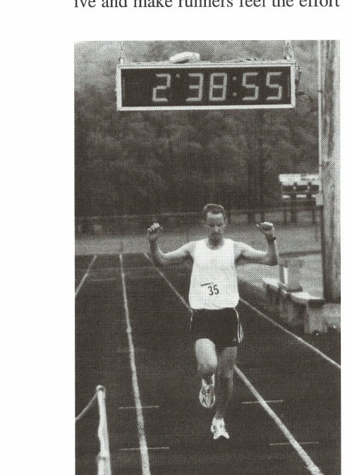
There is a gentle rise into the Coudersport Area Recreation Park with an S-turn onto the six-lane all-weather track. Three-quarters of a lap around the track in a counterclockwise direction, and a very welcome finish line waits at the 50-yard line.
While the race application promised an expo at the finish area, sales of this year’s race T-shirt ($16) and those left from previous years ($10) along with food at a concession stand was all the expo in evidence.
AN ANNOUNCEMENT OF SUCCESS
The announcer does a great job of calling out the names of finishers, giving hometown and personal best (likely not from the God’s Country Marathon course), and his sense of humor is greatly appreciated at that
Runner’s High/Runner’s Low
| HIGHS | LOWS |
|---|---|
| One continuous 17.5-mile hill | One continuous 17.5-mile hill |
| Five-color outstanding race T-shirt | Two-mile downhill after a 17.5-mile climb |
| Your name and hometown announced as you enter the track for your finish | No expo |
juncture. “If you’re using sunscreen, it is to be discontinued immediately,” he called. On this cold and raw day, his comment was right on the money.
The finish-line crew are supportive and make runners feel the effort was well worth it. With only 136 runners, clothing pickup is a snap. There’s plenty to drink at the finish, and there’s also fruit. The finish-area support is superb.
Showers are available at the Wellness Center of the Charles Cole Memorial Hospital where the awards dinner is held. Admission is free to all in attendance, including family members. The event is well attended, and the food is very good for hospital fare.
Driving back toward the start on a point-to-point marathon course while the race is still in progress is a learning experience. Driving backward along the God’s Country Marathon course is a college education. Even though half the field is across the finish line, the other half is still struggling to mount that damned Denton Hill or making their series of turns through town. They are inspiring in their struggles against their own weariness and against gravity.
As scenic as Route 6 is—and it is scenic—it is still a two-lane country road. The shoulders are not very wide, and wobbling, struggling runners are more stable on the roadway than on the gravel sides. Caution at all times is a must for drivers. A lapse on the part of a driver along Route 6 puts runners into jeopardy.
The concentration on the faces of the runners, the distant looks, the hands on knees as they struggle up that massive hill both inspire and raise questions about the sanity of the participants. This is one tough course for the untrained or weak of heart.
The race is like walking through a time warp that takes you back to marathoning’s first boom, when race committees were small, budgets were nonexistent, and the challenge was not for medals or T-shirt but for the satisfaction of covering 26.2 tough miles. A $50,000 first prize and a new convertible are a long way from Potter County.
The God’s Country Marathon in Potter County, Pennsylvania, is as grassroots and challenging as it gets in marathon running today. It’s a tough, unforgiving stretch of woods where deer flourish as well as eager hunters. Running in this part of the country is a welcome step back in time.
The Bottom Line
We have weighed various aspects of a marathon within a 1,000-point scoring grid. Besides the author of the article, two dozen runners at the race were randomly chosen to score the race for us (GCM = God’s Country Marathon). The results follow:
1. HISTORY/TRADITION
Evaluate the race’s sense of history and tradition.
[Possible points: 30 GCM score: 28]
2. ENTRY FORM
Is the race entry form clear, concise, attractive, complete, and easy to fill out?
[Possible points: 20 GCM score: 17]
3. ENTRY COST
For most races, the entry fee covers between 30 and 50 percent of the cost of putting on the event. Rate the value of your dollar relative to this race.
[Possible points: 30 GCM score: 30]
4. LOCALE/SCENICS
Is the race held in an area that is easy to get to and scenic and offers adequate food and housing services and nonrace activities for family and friends?
[Possible points: 50 GCM score: 46]
5. REGISTRATION
Is registration well organized and efficient? Does it bog down unnecessarily?
[Possible points: 20 GCM score: 17]
6. PRERACE ACTIVITIES
Evaluate activities, such as pasta feeds, parties, and so on, during the days before the race.
[Possible points: 50 GCM score: 22]
7. EXPO
Does the expo offer a fair number and variety of booths relative to the race’s size? Are there quality exhibitors and good guest speakers?
[Possible points: 50 GCM score: 0]
8. COURSE
Take into consideration the following: degree of difficulty, certified, sanctioned, quality of road or trail surface, adequate mileage and directional markers, aid stations, medical coverage, race communications, accessibility to course for friends and family, typical weather, and so on.
[Possible points: 400 GCM score: 285]
9. RACE AMENITIES
This category includes race T-shirt, finisher’s medal, finisher’s certificate, adequate and efficient finish area, ease of sweatbag retrieval, showers, postrace refreshments, awards ceremony, raffles, results postcard, results book, and so on.
[Possible points: 250 GCM score: 175]
10. VOLUNTEERS
Are the volunteers experienced and adequate in number?
[Possible points: 100 GCM score: 75]
TOTAL SCORE FOR GOD’S COUNTRY MARATHON
695 points
This article originally appeared in Marathon & Beyond, Vol. 6, No. 2 (2002).
← Browse the full M&B ArchiveMore like this
1,000+ stories from 19 years of Marathon & Beyond
The complete archive of the legendary long-distance journal — digitized and free to read.
